Atlas 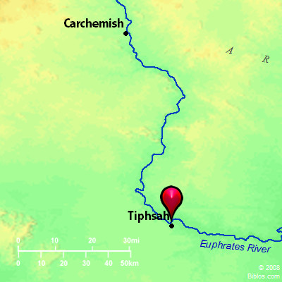 Tiphsah and surrounding area
Maps Created using Biblemapper 3.0Additional data from OpenBible.info
You are free to use up to 50 Biblos coprighted maps (small or large) for your website or presentation. Please credit Biblos.com. Occurrences 1 Kings 4:24 For he had dominion over all the region on this side the River, from Tiphsah even to Gaza, over all the kings on this side the River: and he had peace on all sides around him. Encyclopedia TIPHSAHtif'-sa (tiphcach, "ford"; Thapsa):
(1) This marks the northern extremity of the dominions ruled by Solomon, Gaza being the limit on the South (1 Kings 4:24). It can hardly be other than Thapsacus, on the right bank of the Euphrates, before its waters join those of the Balik. The great caravan route between East and West crossed the river by the ford at this point. Here Cyrus the younger effected a somewhat perilous crossing (Xenophon, Anabasis i.4, 2). The ford was also used by Darius; but Alexander the Great, in his pursuit constructed two bridges for the transport of his army (Arrian iii.7). Under the Seleucids it was called Amphipolis. The site is probably occupied by the modern Qal`at Dibse, where there is a ford still used by the caravans. It is about 8 miles below Meskene, where the river makes a bend to the East.
(2) (Codex Vaticanus Thersa, Codex Alexandrinus Thaira): The inhabitants of this town, which was apparently not far from Tirzah, did not favor the regicide Menahem, refusing to open to him. In his wrath he massacred the Tiphsites with circumstances of horrible cruelty (2 Kings 15:16). Khirbet Tafsah, about 6 miles Southwest of Nablus, corresponds in name, but is probably too far from Tirzah.
W. Ewing Strong's Hebrew H8607: Tiphsacha place on the Euphrates |
    |